-40%
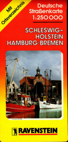
Schleswig-Holstein Hamburg Bremen Road Map 1:250,000 Ravenstein Germany Deutsche
$ 6.85
- Description
- Size Guide
Description
Schleswig-Holstein Hamburg Bremen Road Map 1:250,000 Ravenstein Germany DeutscheSchleswig-Holstein Hamburg Bremen Road Map 1:250,000 Ravenstein Germany Deutsche
Schleswig-Holstein Hamburg Bremen Road Map with Separate Index
Deutsche Strassenkarte 1:250,000
Ravenstein Germany Road Map
Ravenstein maps are known worldwide for their detail, accuracy and beautiful coloring. Until the late 1990s, when it was finally sold to a conglomerate, Ravenstein Verlag was the world's oldest independent map maker. They were based in Germany just outside of Frankfurt am Main.
The Ravenstein cartographers have divided Germany into 11 regions, each with its own map at the very generous scale of 1:250,000 (1 inch : 4 miles or 1cm: 2.5km).
This is a folded map in protective card wraps (covers). The map is unused with minor shelf wear to wraps not affecting the
map itself. It is indexed.
1997/98 edition.
Multi-lingual legend—German, English, French.
Colorful map, easy on the eyes, easy to find places of interest.
Size folded: 4 3/4" x 10".
Size unfolded: 35½" x 39".
Topography is shown by relief shading with coloring for woodlands and names of mountain ranges.
National parks and other protected areas are highlighted.
Road network gives driving distances on many local routes and shows border crossings.
Main railway lines are included, as well as mountain railways and funiculars, also car ferries by rail.
Symbols highlight various places of interest including campsites, golf courses, monasteries, mountain inns, castle ruins.
Separate index - a booklet affixed to the inside of the rear wrap.
Protective card cover.
Unused with minimal shelf wear.
ISBN 3-87660-204-1
FREQUENTLY ASKED QUESTIONS
DO YOU ACCEPT RETURNS?
Yes - HASSLE FREE returns for any reason.
We accept returns for 30 days after delivery date.
All returns must be in original condition.
No re-stocking fee.
If the reason for a return is OUR FAULT, we'll refund the return shipping in addition to the cost of the item returned. If the reason for return is NOT OUR FAULT you will be expected to pay for return shipping and the cost of shipping to you will be deducted from the refund.
Please contact us via ebay if you are not 100% satisfied with your purchase.
WHEN IS PAYMENT DUE? WHAT DO YOU ACCEPT?
Auction winners must claim and pay for their item within 3 business days.
Ebay requires Immediate payment on Fixed Price items.
We accept payments through PayPal only.
WHEN DO YOU SHIP AND HOW?
We Ship via USPS Monday thru Friday. Your order will ship in one or two business days after payment is received.
FREE domestic STANDARD shipping
Domestic Priority shipping available on items weighing up to 4 lbs that fit in the Flat Rate Envelope provided by the USPS. The rate we charge is discounted by the amount of Standard Domestic rate.
Reduced International shipping by the amount of Standard Domestic rate
Tracking for every parcel, including many international destinations. We email you the tracking number.
The items are packed in cardboard book folds for maximum protection.
Listing and template services provided by inkFrog


